Ride Information
- Distance 64 miles (103km)
- Climbing 1662m (5109ft)
- Grade Medium hard – nothing ridiculously steep but one long climb. A compact chainset is recommended
- Maps OS Landranger 136 Newtown & Llanidloes, 137 Ludlow, Church Stretton &
- Wenlock Edge, and 147 Elan Valley & Builth Wells
- Download the route here
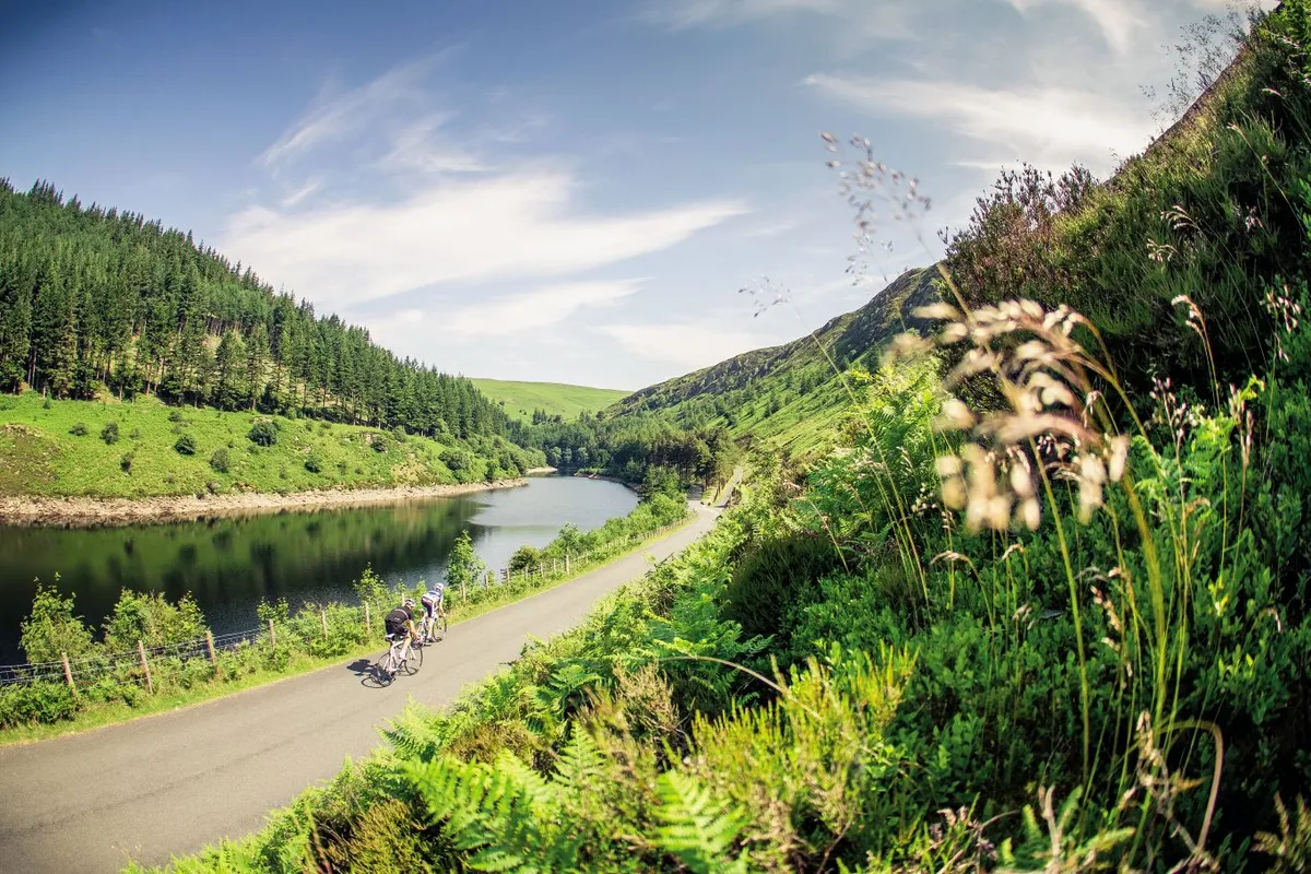
Climbing out of the shadow of the 120ft-high Caban-coch dam, it’s like we’ve been transported to a southern European lakeside, as brilliant sunshine flashes off a lake surrounded by steep, wooded hills. It’s no wonder they call this the Welsh Lake District. The views are simply breathtaking, and you quickly forget that this lake and the four other reservoirs here are man-made, covering an area of 1500 acres – not to mention the homes, church and school of 100 rural Victorians.
As we round the first shoulder of headland, an elegant bridge stretches across the valley above the water to our left. It’s actually another dam, submerged this time, to keep water in the higher Garreg-ddu Reservoir in times of drought. It’s hard to imagine this landscape is ever dry, as even on this scorching hot day the sound of running water is everywhere.
Rounding the headland, we head for the top of the valley where the steep, wooded slopes pinch together and our road disappears into the cool shade of tall, fresh-smelling pines. First, though, we cross the shared use Elan Valley Trail on the 109-year-old railway path laid to build the dams. It has followed the lakeside below us since we started, but now rises above us to gain height at the head of the valley.
Reservoir slog
Our road wasn’t built for trains, though, and isn’t shy of steep gradients or sharp corners. We soon find both, as our route hooks back on itself over a humpback bridge, before winding round a hairpin bend that’d look more at home in the Alps.
“The next two miles are all climbing,” says Ed Matysiak, the Cycling Plus reader whose favourite ride we’re following, “but we ride down it on the way back.” There’s plenty of reward going up too, as our climb through the pines suddenly reveals a huge waterfall. In reality it’s again man-made, the overflow water of the Penygarreg Reservoir cascading over its dam.
A few minutes later, we’re climbing above the lake to the west and its full length is laid out below us, with a perfectly proportioned wooded island dropped in at one end.
The beauty of these man-made landscapes just keeps on revealing itself. As we top out over the northern end of Penygarreg Reservoir, another even more expansive body of water stretches into the distance from its own dam – a huge sloping wall with a many-arched road bridge running along the top. This is Craig Goch, the highest and last of the Elan reservoirs, whose dam was built over 110 years ago by Birmingham industrialists to bring clean water to their thirsty, dirty city. The dam on its southern end is also where the Elan Valley Trail finishes, and is as far as King Edward VII got when he came to open the scheme in July 1904.
We carry on, though, over a narrow single-arch bridge heading north across the shallow slope of the lake’s western shore. The landscape is much more open here, and we’re surrounded by grasslands covered in patches of sometimes white, sometimes yellow wild flowers. The views east are over the Craig Goch reservoir, with smooth, pleated, grassy hills rising straight out of the opposite edge of the lake to rounded grassy hilltops above.
At the far end of the lake, we descend steeply to a sheet iron bridge and cross the River Elan – the real architect of this valley’s spectacular scenery. On the other side, we have to climb a ramping pair of hairpins to the crossroads above. “We’ll be coming down from up there later,” says Ed, pointing to our right, where the road climbs high out of sight.
Tarmac treat
After the hairpin we set off northwest, on an undulating road at the back of the valley above the now shallow and stony upper reaches of the river. The sun is beating down on this beautifully barren and peaceful valley, before a short climb round a corner reveals yet another mouthwatering piece of tarmac.
The road ahead drops down to wiggle through the narrow head of a new valley cut by the River Ystwyth and we can see it reappearing in the distance to round each interlocking buttress as the river deepens in the valley below. “The next six miles are all pretty much downhill,” says Ed, as we start to devour the tarmac treat laid out in front of us. Next to us, the river – as yet just a brackish stream – twists and gurgles, weaving round rocks like giant sugarcubes by the roadside.
A couple of miles further on, the valley starts to widen and we drop down and cross the river to ride along its northern side. “This is where it starts getting slatey,” says Ed, as suddenly the valley side we’re traversing turns into an enormous scree slope of flat stones and we ride past abandoned stone buildings and open mining works. Crossing a cattle grid, vegetation starts to grow again, and we quickly pass the hamlet of Cwmystwyth, which has more consonants than houses.
A steady, two-mile climb follows, but it passes almost unnoticed as someone wolf-whistles me. It’s certainly not Ed, and there aren’t any short-sighted scaffolders working nearby – instead, it turns out to be red kites, circling above us, their distinctive fork tails giving them away. By the end of today I’ll have seen about a dozen, which suggests their reintroduction is proving a success in this area...
At the top of the climb the road sweeps into pine woodlands, and it’s like we’ve been transported to the Scottish Highlands. There’s a seemingly random stone archway on the top of the hill – though apparently it was built to mark King George III’s Golden Jubilee in 1810. One fast, exciting, two-mile descent later and we arrive in a village with ultimate arch-appeal, Devil’s Bridge.
Electing to buy a coffee instead of paying to walk down hundreds of steps in cleats, we don’t get to appreciate the sight of the three bridges stacked on top of each other across the ravine, nor the 300ft-high Mynach Falls, nor even the narrow gauge steam train that comes the 12 miles from Aberystwyth on the Welsh coast.
I’m grateful for a quick rest though – this is the hottest day of the year yet, and the mercury is still rising. So, too, is the road again for a mile from here, though thankfully through shady woodland. This time we’re roughly following the River Rheidol northwest on the A4120. The main road isn’t too busy and a few miles further on, we turn off right to cut the corner anyway, only rejoining the even bigger A44 to push further east towards the Wye Valley.
High pass headwind
Pushing is the operative term – pedals, not bikes – as these first three miles of the A44 are a steady graded climb around the head of a valley all the way to the 1339ft-high pass of Eisteddfa Gurig. The payback should be a steady three-mile descent to the River Wye itself but it isn’t, because almost as soon as the wide road starts gradually pointing downhill a headwind comes out of nowhere and we have to pedal all the way to the bottom.
We continue following the Wye for another four miles – at first having to climb the side of the valley above the river for a mile, then descending all the rest of the way to Llangurig, turning off south onto a minor road to cross the river and its flood plain.
Running from here to near Chepstow on the Severn Estuary, the River Wye is close to Ed’s heart – fishing is his other passion and this is the river he’s spent long summer days in and around as it runs through his home town of Hereford, an hour-and-a-half’s drive away.
The quiet, hedge-lined lane we’re now following snakes along the verdant valley, the Wye gaining size on our left with every mile. Above it, on the opposite side of the valley, runs the main road which Ed says he takes instead if he’s in a hurry. Ours is narrow and winding but not exactly slow, and we spin on through the amusingly named Pant-y-drain to an easily-missed right turn – straight on leads to the A470.
But we’re in no hurry – which is just as well, as a few miles down the road the surface starts to get more patchy, and we have to let ourselves through a succession of farm gates. The traffic-free seclusion and scenery is worth it, though, and even a quickly fixed pinch puncture picked up from a mistimed pothole-bunnyhop doesn’t spoil the mood.
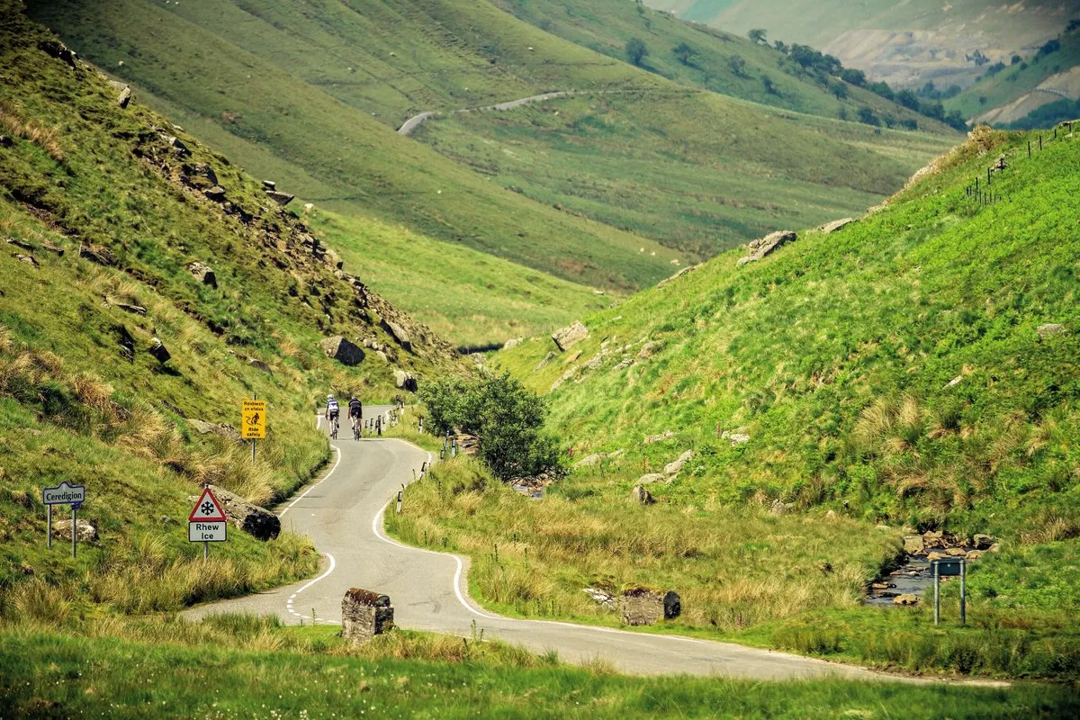
Just as I’m getting used to the easy-paced up and down meandering, our little lane drops us to the edge of Rhayader. The colourful, busy little town would be an excellent place for a pie and pint, if only we didn’t have another 14 miles to ride – starting with the day’s biggest climb. At 2.2 miles long, with an altitude gain of 793ft and an average gradient of 6.8 per cent, it’s not exactly Mont Ventoux, but it does have a few surprises up its sleeve.
The first mile is shallow, and typically, it isn’t until we cross a cattle grid that the real climbing starts. As we quickly rise above the valley floor, down below to our left there’s a picturesque little lake. Or is it a large pond? My legs are saying ‘who cares?’ as we climb along a wonderfully shady stretch of road. Soon I’m not saying anything at all as the effort starts to take its toll and we emerge from the shade into the glaring heat, with the sun bouncing off the road and scree slopes above us.
The scree then gives way to fern-covered slopes and I can see the top, where the stream cuts through a rocky outcrop. “Don’t be fooled,” warns Ed, “this one just keeps on going.” It certainly does: we don’t actually top out until after another mile of moor-top mashing and another 262ft of ascent.
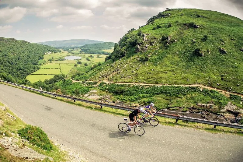
The views at the top are ample reward, as the landscape opens up to the north and west down to the top of Craig Goch Reservoir. It’s a cracking descent too, and we streak down the mile and a half to the sheet iron bridge over the River Elan that we crossed hours ago.
Apart from the odd blip, the last 10 miles are all downhill, as we retrace our tyre tracks of the morning. It’s rarely such a treat to ride the same piece of road twice in a day but the views of the lakes are stunning in this direction too. The added bonus is that the downhill return means we get to turn all those steep, sharp uphill bends of our outward journey into exhilarating, descending fun, before finally cruising back above the still-shimmering waters of Caban-coch.
Local Knowledge
Nearest station
Llandrindod Wells
Food and drink
There is a cafe at the Elan Valley Centre, and pubs and cafes in Rhayader. The Black Lion pub in Llangurig is also on the route
The Bluebell Inn in Llangurig is on the route; Beili Neuadd B&B is in Rhayader, and the Elan Valley Trust rents out self-catering accommodation www.elanvalley.org.uk
Clive Powell in Rhayader repairs and sells road bikes and there is bike rental at the Elan Valley Centre
Images: Laurence Crossman-Emms
Subscribe to Cycling Plus
For inspiring rides every month subscribe to Cycling Plus magazine. Click here for our latest subscription offer.

