Ride Information
- Distance: 152 miles (245km)
- Grade: Hard. The terrain isn't too taxing but the distance is. Plenty of daylight though!
- Download the route here
Lying 400 miles south of the Arctic Circle on the same latitude as Alaska, Greenland and St Petersburg, and reached via a 225-mile ferry crossing – about the same distance away Norway lies to the east and the Faroe Islands to the north-west – Shetland doesn’t sound like part of Britain. Its quiet and immaculately surfaced roads make it sound even less so. But thanks to King Christian I of Denmark and Norway – who when his daughter married James III of Scotland in 1468 pawned Shetland to Scotland because he didn’t have the money to pay her dowry – and North Sea oil – a small percentage of the money from which gets invested into the islands’ infrastructure, most notably the roads – this Arctic archipelago is indeed both British and a cycling haven.
Shetland also has more daylight hours during summer than anywhere else in the UK so you have the perfect destination for long days in the saddle. Even the weather isn’t as bad as its position on the map suggests. It’s not as wet as in many other north-western parts of the UK and thanks to the influence of the sea it’s not as cold as other places on the same latitude. The biggest downside for a cyclist is that it can be very windy, but it’s much less so during the summer months.
ENDLESS DAYS
Joining me on the ride was Shetland Wheelers’ sport development officer Robin Atkinson. It’s the only club on the islands, which means it’s also the most northerly cycling club in the UK. The day I arrived the annual 50-mile Simmer Dim sportive that Robin helps to arrange was taking place. We’d borrowed part of the route to plot this Big Ride, so it only seemed polite to invite him along.
Despite the 245km that lay ahead, we didn’t head off at the crack of dawn because there wasn’t one. We were in Shetland in mid-summer when it never actually gets dark, there’s just a lingering twilight, known as the Simmer Dim. Since we were never going to run out of light we put together a ride that made the most of the endless day ahead.
We met at the Shetland Museum and Archives in Lerwick, the islands’ capital, which makes for a convenient spot to quickly get out of town – although wherever you start you’re not going to be fighting rush-hour traffic and suburban sprawl. There’s also a great pre- or post-ride coffee option at the arts centre cafe next door, known as the Mareel.
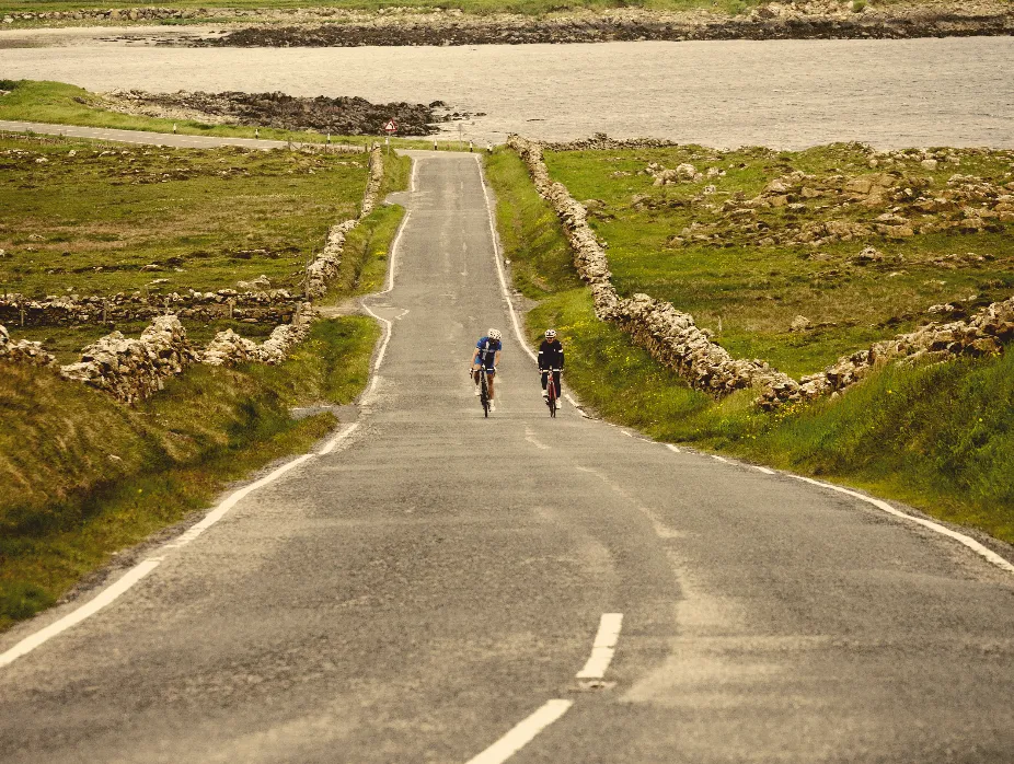
It was a hill start as we headed out of Lerwick and this was by no means the first and last climb of the day. I’d been to one Scottish island before in the inner Hebrides where the terrain was rolling but had no real lumps to speak of, so I’d made the incorrect assumption that Shetland would be similar. While I only saw one sign indicating a steep gradient – of nine per cent – there are plenty of steady, long mid-gradient climbs and it’s rarely flat.
After ascending out of Lerwick we dropped down into a valley, after which another of those mid-gradient climbs greeted us. At the top, surrounded by fields and loch-dotted moorland, we joined a singletrack road that took us back out towards the sea and alongside spectacular rugged coastline. Except for the main roads, which cut through the middle of the islands, singletrack roads are the norm. But they’re not like singletrack roads I’ve come across anywhere else in the UK. When confronted with oncoming traffic in Shetland there’s no throwing yourself into a hedge while avoiding the potholed and broken up road edges. Here the singletrack roads have good-sized, regular, purpose-built passing areas and they’re just as well maintained as the main roads, while being even quieter. Another plus is that the landscape is largely hedge- and treeless, so most of the time you have a good view down the road, enabling you to see approaching vehicles well in advance.
As we turned back inland through moorland that stretched as far as the eye could see we headed up another enjoyable climb before rejoining the A970. From here it was a stretch of steady, almost continual climbing before we again found ourselves alongside the coast, this time on the west of the mainland. Brae was the next town we came to, home to what is officially the UK’s best fish and chip restaurant. That’s reason enough to do more than just pass through like we did, but Brae makes an ideal alternative start and finish point for the ride if you’d prefer to split it over a couple of days, doing the northern loop one day and the mainland loop the next.
Heading out of Brae I started to get the feeling of remoteness I’d expected from the moment I stepped off the ferry from Aberdeen. While only 15 of Shetland’s more than 100 islands are inhabited, with the rest given over to huge bird colonies and other wildlife, it’s still home to 22,000 people, so, on the mainland at least, it doesn’t feel as isolated as you may think. The biggest communities such as Lerwick and Scalloway in particular are cultural hubs. Away from more populated areas, you quickly lose the ‘crowds’. Cycling past the huge oil terminal at Sullom Voe (voe is Scottish for a small bay or narrow creek) was a jolt back from my sense of creeping other-worldliness, but also a reminder of these islands’ distant location.
ISLAND HOPPING
Running out of mainland we arrived at the ferry port to continue our journey north. The journey takes around 20 minutes, which I discovered is barely enough time for a toilet stop and a wrestle with the vending machine. Aside from the wind, the one other downside about Shetland for a cyclist is the irregularity of cafes, so you have to grab a coffee where you can.
Before we’d set off Robin had described Yell as little more than a through road to Unst. Mostly moorland and rough grazing. It’s true that Yell doesn’t have the scenery found in other parts of the islands, but it has its own charm if wild and windswept is your thing. It also boasts two of Shetland’s three tombolos – a natural phenomenon where a beach or bar, created by waves, connects two landmasses – but even these weren’t as impressive as the one we’d seen the previous day at St Ninian’s Isle on the mainland. Shetland has a spectacular coast featuring all kinds of geological formations such as stacks, natural arches, caves and blowholes, so it’s worth keeping an eye out when the sea appears.
We pressed on across all 19 miles of Yell with the promise of a cafe at the ferry port in Gutcher keeping me going against the relentless head wind. It wasn’t until reaching for the cafe door that I noticed the paint pots and dust sheets. So, instead, we watched the dive-bombing gannets while we waited for the boat. They were clearly having more luck finding a mid-morning snack.
ALL ROADS LEAD NORTH
It was just a 10-minute journey across the sea to Unst, the most northerly inhabited island in Britain. Approximately 12 miles long and five miles wide, there’s only one way through it until the road splits at Haroldswick just after a Viking boat. Straight on takes you to the UK’s most northerly point, but we turned right to the NCN’s most northerly point. As we passed a sign to Britain’s most northerly church I wondered if the NCN would be similarly marked. It wasn’t, so we just kept riding along route 1 until we ran out of road and ended up on someone’s drive.
A beautiful bay ran alongside the final section and with the waves crashing onto its sandy shore and feeling the full force of a cross wind it really felt like we were at the end of the Earth never mind Britain. As we turned round to begin our journey south, the road was oddly busy. A bin lorry was doing its rounds – even up in such a stunning, remote location the humdrum of everyday life still goes on.
We started to retrace our route and couldn’t resist a stop at the most welcoming bus shelter you’re likely to find, featuring a sofa and some books. I got the feeling the wait for a bus can be a long one round here. As we neared the ferry port, equally hard to ignore was a group of Shetland ponies and their foals.
Back on Yell we took the singletrack road from Mid Yell that runs along the eastern coast down to Burravoe in the south-east corner. An attractive village, Burravoe is home to the Old Haa Museum, which is housed in an old merchant’s cottage. Crammed with local history, it’s worth a visit not least because there’s also a tearoom offering a good selection of cakes.
TIFFIN TIME
From the ferry a fun, long, relaxed descent alongside the spectacular Dales Voe took us back to Brae from where we continued our journey south along the west side of the mainland. A particularly enjoyable section from Voe to just beyond Twatt (stop giggling at the back) on the B9071 took us along more singletrack roads and through an area Robin dubbed the Alps, which as the name suggests is hilly (mountainous is stretching it), barren and beautiful terrain with steady climbs and sweeping descents. I was so absorbed in the fun I forgot to look out for a fridge stocked with homemade cake outside a house just before Aith. Fortunately Robin didn’t. He’d told us about it even before we’d set off and particularly talked up the tiffin. I can confirm it was incredible and worth a visit to Shetland in itself.
Rejoining the main road, the toughest climb of the day in the shape of a long drag, which Shetland Wheelers use for their annual hill climb, rewarded us with views across Weisdale Voe, the kind of sight you associate more with Norway than the UK. Instead of retracing our steps into Lerwick we went back via the picturesque village of Scalloway. Our route didn’t take us through the centre but up another steady climb we could see the town below with the castle and harbour in the distance and the red timber-frame Scandinavian-style houses in the foreground.
Unsurprisingly, we arrived back in Lerwick with plenty of daylight in hand. You may only be able to ride just under 100km without covering the same bit of road twice on Shetland (a Robin fact) but even after cycling 245km in one day there were still many parts of the islands, mainly on the mainland, we hadn’t been to, so there’s plenty of scope to make a cycling holiday of your visit. Forget John O’Groats, Shetland is the UK’s ultimate northern cycling destination.
LOCAL KNOWLEDGE
GETTING THERE
Northlink Ferries (northlinkferries.co.uk) runs a service between Aberdeen and Lerwick seven nights a week. Flybe has flights to Sumburgh on the southern tip of the mainland from most of Scotland's major cities.
GETTING AROUND
Unless you're cycle touring we recommend hiring a car. We used Bolts (boltscarhire.co.uk). The ferries between the islands largely run to a timetable, see shetland.gov.uk/ferries/timetable. asp. Bikes are free, so you just pay a passenger fare.
FOOD AND DRINK
We recommend the Old Haa Museum in Burravoe, Busta House Hotel in Brae, Frankie’s Fish & Chips in Brae, and the Mareel cafe in Lerwick. And of course the fridge!
WHERE TO STAY
The Lerwick Hotel (shetlandhotels.com) and Queen's Hotel (kgqhotels.co.uk), Lerwick, Busta House Hotel (bustahouse.com), Brae.
WHAT TO DO
Sumburgh Head is great for seeing puffins. For walking and cycling, the tourist office in Lerwick has maps. Lerwick Museum and Archives, and Scalloway Museum are worth a visit.
TOURIST INFO
Subscribe to Cycling Plus
For inspiring rides every month subscribe to Cycling Plus magazine. Click here for our latest subscription offer.